4D GIS Traffic Planning and Visualization
- Project
- 18036 SMART
- Type
- New product
- Description
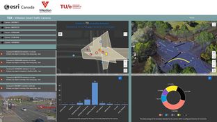
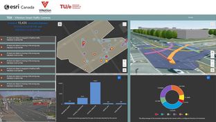
A cloud-based geographic information system for efficient operation in transportation. Ingesting real-time traffic metrics and data from the ViNotion camera, we can visualize anomaly trends over time to study intersection safety. One challenge of road safety is to understand road user risk - traffic anomalies contribute to road user risk. Seeing the occurrence of these over time provide insights and decisions to improve safety. This tool utilizes the precise geo-location of the incident, incidents are categorized, reported in real-time and are also aggregated over time to visualize patterns
- Contact
- Jennifer Overbury, Esri Canada Limited OR Egbert Jaspers, ViNotion B.V. (egbert.jaspers@vinotion.nl)
- joverbury@esri.ca
- Research area(s)
- Road User Safety, Data Visualization, Real-time Data Integration
- Technical features
This is built on the ArcGIS Online platform and ArcGIS Velocity. Relies on AI enabled cameras developed by ViNotion and TU/e.
- Integration constraints
This is a packaged solution that includes all necessary components to install within an ArcGIS Online Velocity environment.
- Targeted customer(s)
Any road authority, traffic planners, road safety analysts (e.g. vision zero programs)
- Conditions for reuse
Customer requires licenses for ArcGIS Online and ArcGIS Velocity.
- Confidentiality
- Public
- Publication date
- 31-12-2023
- Involved partners
- Esri Canada Limited (CAN)
- ViNotion BV (NLD)
- Eindhoven University of Technology (NLD)
Images