Dynamic Parking Analytics in GIS Using Data from Multiple Vendors
- Project
- 18036 SMART
- Type
- New product
- Description
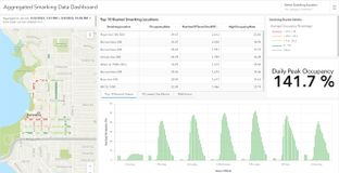
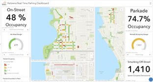
Urban Parking Analytics in GIS. Utilize real-time data feeds to visualize current occupancy of street and garage parking for constituents on a map. This can reduce ‘trolling’ for parking in urban streets. Aggregation of real-time data reveals patterns and data insights that support decisions for dynamic pricing and future planning.
- Contact
- Jennifer Overbury or Arif K. Rafiq, Esri Canada Limited
- joverbury@esri.ca
- Research area(s)
- Real-time data analytics, Urban Parking, Parking Dynamic Pricing, Transportation digital twin, Transportation GIS, Data Aggregation and Visualization
- Technical features
Map visualization of real-time data feeds from multiple vendors providing observations of street and garage parking status. Big Data Analytics within ArcGIS Velocity feed a parking analytics dashboard that visualizes parking occupancy and vacancy over time; by hour, day of week etc. Easily identify when occupancy level approach or exceed user definable thresholds to balance dynamic pricing decisions.
- Integration constraints
This is a configured solution that includes necessary components to install within the ArcGIS environment. Additional configuration is required depending on API or data feed from vendor sensor solutions.
- Targeted customer(s)
City Parking Planners, Parking Authorities, Traffic Planners, GIS departments, Municipal Constituents
- Conditions for reuse
Customer requires licenses for ArcGIS Online and ArcGIS Velocity. Customer must have access to sensor systems that report parking occupancy/vacancy (e.g. Mistall Insight Inc. or Smarking Inc, Eleven-X)
- Confidentiality
- Public
- Publication date
- 31-10-2023
- Involved partners
- Esri Canada Limited (CAN)
Images