Building wildfire resilience with intelligent interoperable digital twins
Wildfires are becoming increasingly severe because of accumulated fuel loads from a century of fire suppression and the expansion of the wildland-urban interface. This creates growing risks for communities, infrastructure, insurers, land managers, and emergency responders. Addressing this challenge requires more than isolated models or static risk maps. It demands intelligent systems that can continuously integrate data, simulate changing conditions, and share insights across organisations and technologies.
The ITEA project I2DT (Intelligent Interoperable Digital Twins) aims to advance the next generation of digital twin technologies by making them intelligent, secure, and interoperable across complex environments. The project consortium, comprising partners from Canada, Türkiye, Sweden, Portugal, Spain and South Korea, applies this vision in four use cases: Smart Parking, Wildfire Protection, Data Centre Optimisation, and Renewable Energy Resource Management.
Fire Likelihood AI Model
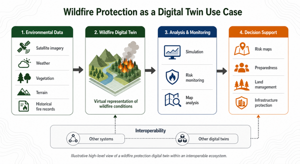
In the Wildfire Protection use case, FLAIM (Fire Likelihood AI Model) implements the I2DT architecture to support wildfire risk modelling. At the data collection and ingestion layer, FLAIM integrates heterogeneous data sources, including satellite observations, weather and climate data, topography, land use, disturbance history, and vegetation characteristics. These datasets are continuously updated and processed to create a virtual representation of wildfire-related environmental conditions.
At the analysis and simulation layer, FLAIM uses deep learning to combine Earth observation data with recorded fire outcomes, generating spatially explicit estimates of burn likelihood at high resolution. The model is designed to evolve as new satellite observations, environmental data, and fire records become available, allowing it to remain responsive to changing climate conditions, land-use patterns, and disturbance regimes. In addition to fire likelihood, FLAIM can estimate fuel hazard by distinguishing the influence of relatively stable vegetation and environmental factors from rapidly changing weather conditions.
The results produced by FLAIM become actionable insights for stakeholders involved in wildfire management, infrastructure protection, insurance, and climate adaptation. They can be delivered as probability surfaces, fuel hazard maps, or risk classifications in standard geospatial formats such as GeoTIFF. These outputs can support wildfire risk assessment, infrastructure protection, land-use planning, fuel management prioritisation, emergency preparedness, insurance decision-making, and climate adaptation planning.
By using an interoperability framework based on the open-source platform Eclipse Ditto, FLAIM can securely exchange information with other digital twins and external systems. In doing so, it demonstrates how a domain-specific wildfire model can become part of a connected digital twin ecosystem. This use case provides a tangible example of the broader I2DT vision: secure, interoperable, and intelligent digital twins that transform complex data into practical decisions, helping organisations build resilience and prepare for increasingly dynamic risks.
More information:
- Project website: https://i2dt.org/
- Wildfire use case team: https://skyforest.io/ | https://emtechgroup.com/
- Project video: https://www.youtube.com/watch?v=8ui1yRSsvJg